Section 38 application at Alfold
Proposed works to facilitate an access road to the referenced development in Alfold across the common land.
Why are we consulting?
This consultation is in advance of the submission of an application under Section 38 of the Commons Act 2006 for consent from the Secretary of State to carry out works on a narrow section of registered Common Land that would be affected by a proposed housing development on adjoining land.
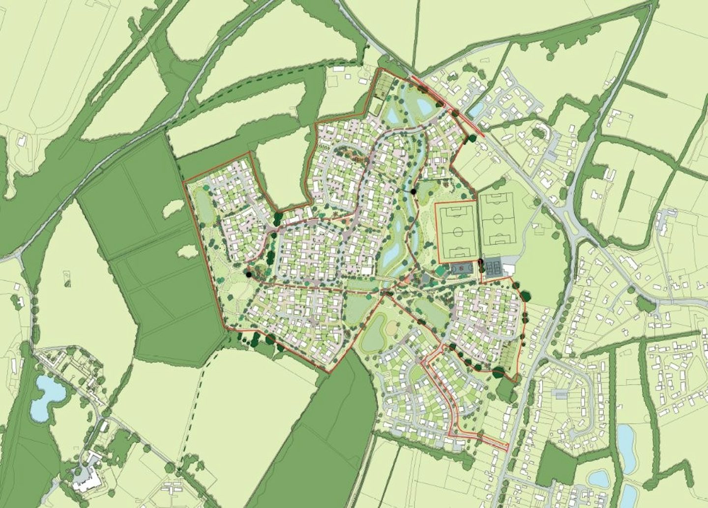
The works proposed within the registered Common Land are required in order to facilitate the required access into the proposed adjacent development site at Land South of Dunsfold Road, Alfold Crossways (‘the Site’). An Outline planning application for the development of this land was submitted to Waverley Borough Council in January 2025 (LPA Ref: WA/2025/00219) and sought permission for the erection of up to 400 homes and associated infrastructure.
As part of this initial informal consultation, consideration has been given to the Common Purpose “A Common Purpose: A Guide to Community Engagement for Those Contemplating Management on Common Land” 2012 document. As recommended in this document, this page sets out a description of the works required, and the replacement land benefit that could be provided within the site.
This early-stage informal consultation is seeking to gather all views from possible stakeholders relevant to the Common Land in question. As well as general observations and comments, feedback in regard to other key areas is also welcomed, including: nature conservation, conservation of the landscape, the protection of public rights of access to any area of land, and the protection of archaeological remains and features of historic interest.
The list of consultees that have been directly contacted is provided below:
Alfold Football Club
Alfold Parish Council
Alfold Sports and Social Club
Alfold Village Hall
English Heritage
Godalming & Haslemere Ramblers
Historic England
Linden Farm Gardening Group
Local Archaeology service
National Landscape Conservation Board
Natural England
St Nicholas Church Faith and Youth Group
Surrey County Council
The British Horse Society
The Open Spaces Society
Waverley Borough Council
Once submitted, the Section 38 application and accompanying documents will be available for public inspection at a suitable location, for at least 28 days.
Where is the Common Land?
The Common Land (hereafter referred to as ‘the Land’) that is subject to the Section 38 application is located to the west of Alfold Crossways, within the Parish of Alfold, in the jurisdiction of Waverley Borough Council in Surrey. The land lies close to the West Sussex border around 6km south-west of Cranleigh, approximately 14km to the west of Horsham and 15km to the south of Guildford.
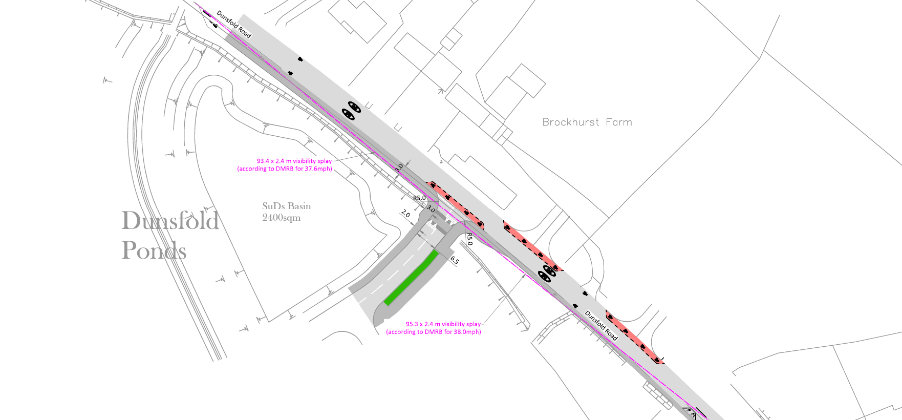
The land in question relates to a small section of Common Land that is located within the narrow strip demarked by blue hash lines in the figure below.
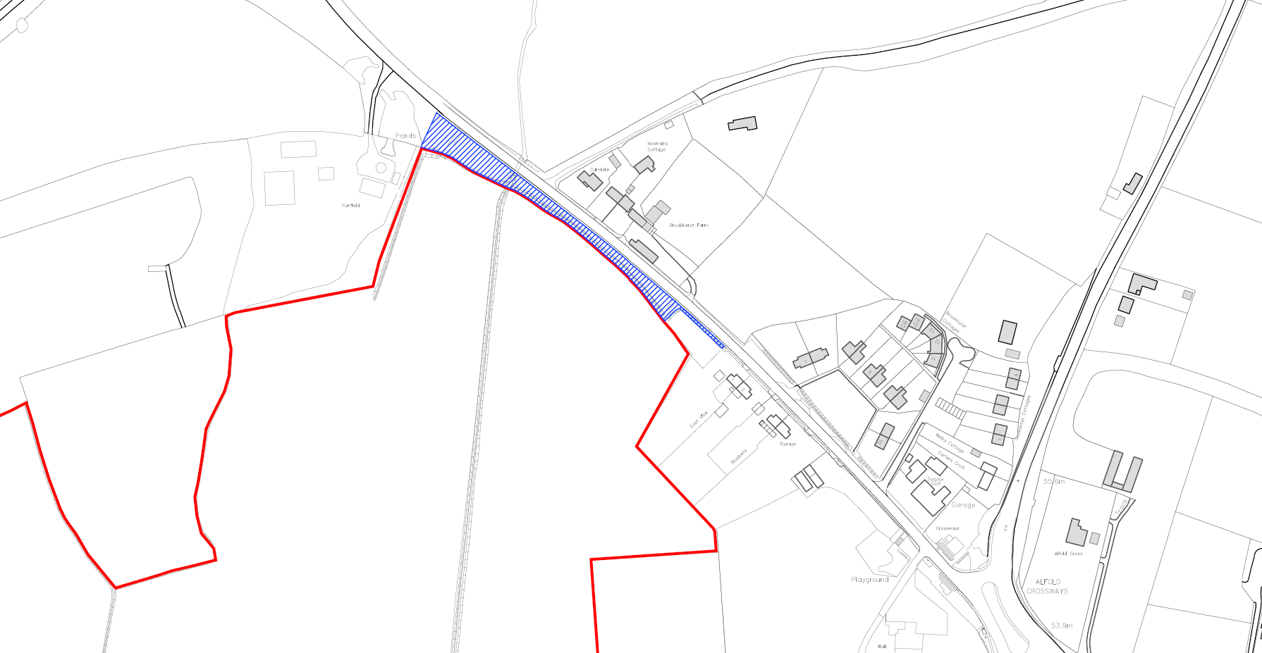
The land comprises a narrow linear strip of grassed verge situated immediately adjacent to the western edge of Dunsfold Road. The strip runs parallel to the carriageway and is separated from the highway by a concrete kerb.
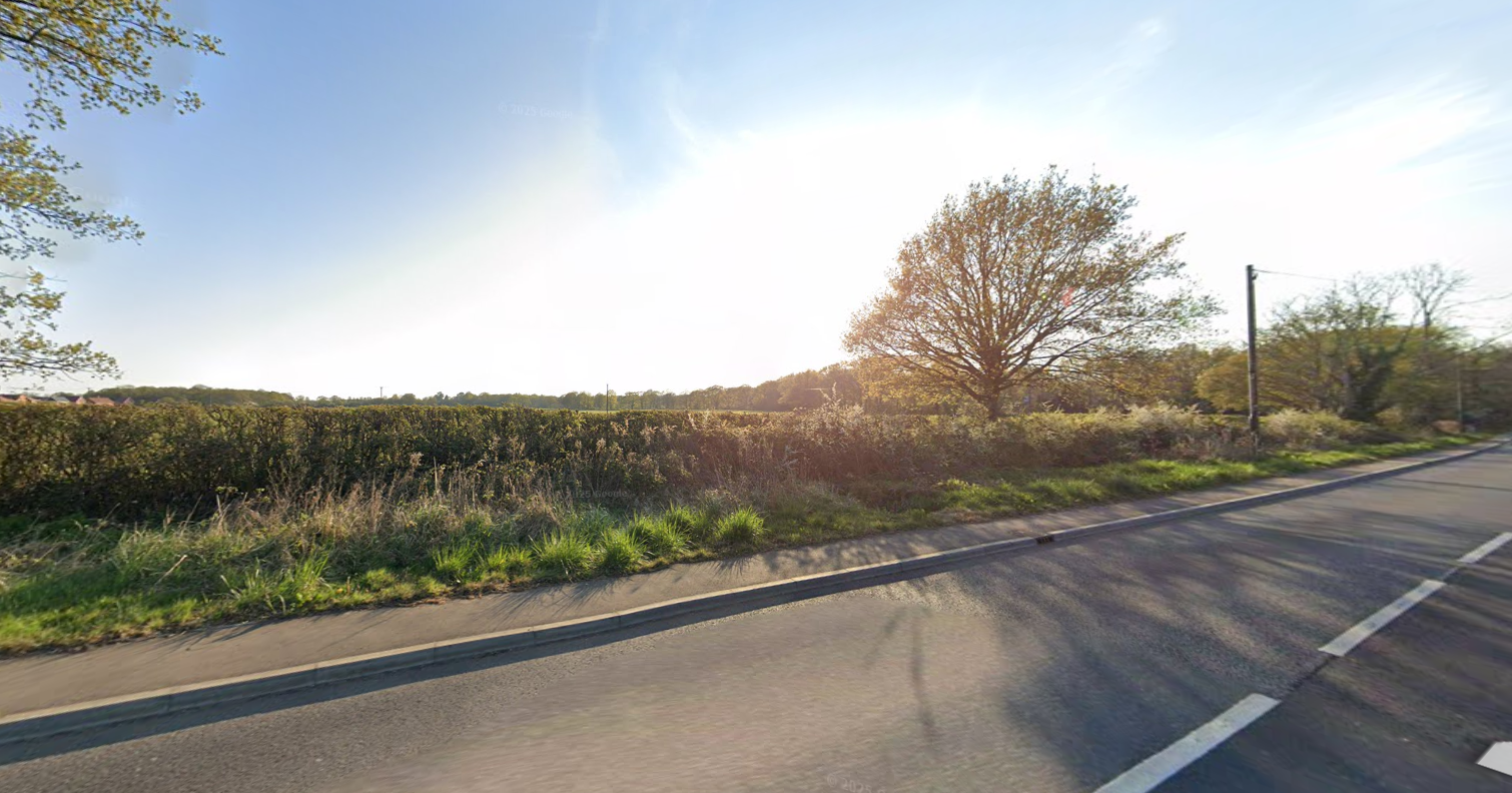
Beyond the grass verge, the land is bounded by a hedgerow comprising shrubs and brambles, which delineates the edge of adjoining the site land. The strip is currently unfenced, and consists of unmanaged gras interspersed with low-growing wild vegetation.
The land is in a natural state with no hard surfacing, structures, or signage present. It is proposed that the Section 38 consent will allow the construction of an access across this strip to facilitate entry to the development site located immediately beyond the hedgerow. An image of the current condition of the land is shown below.
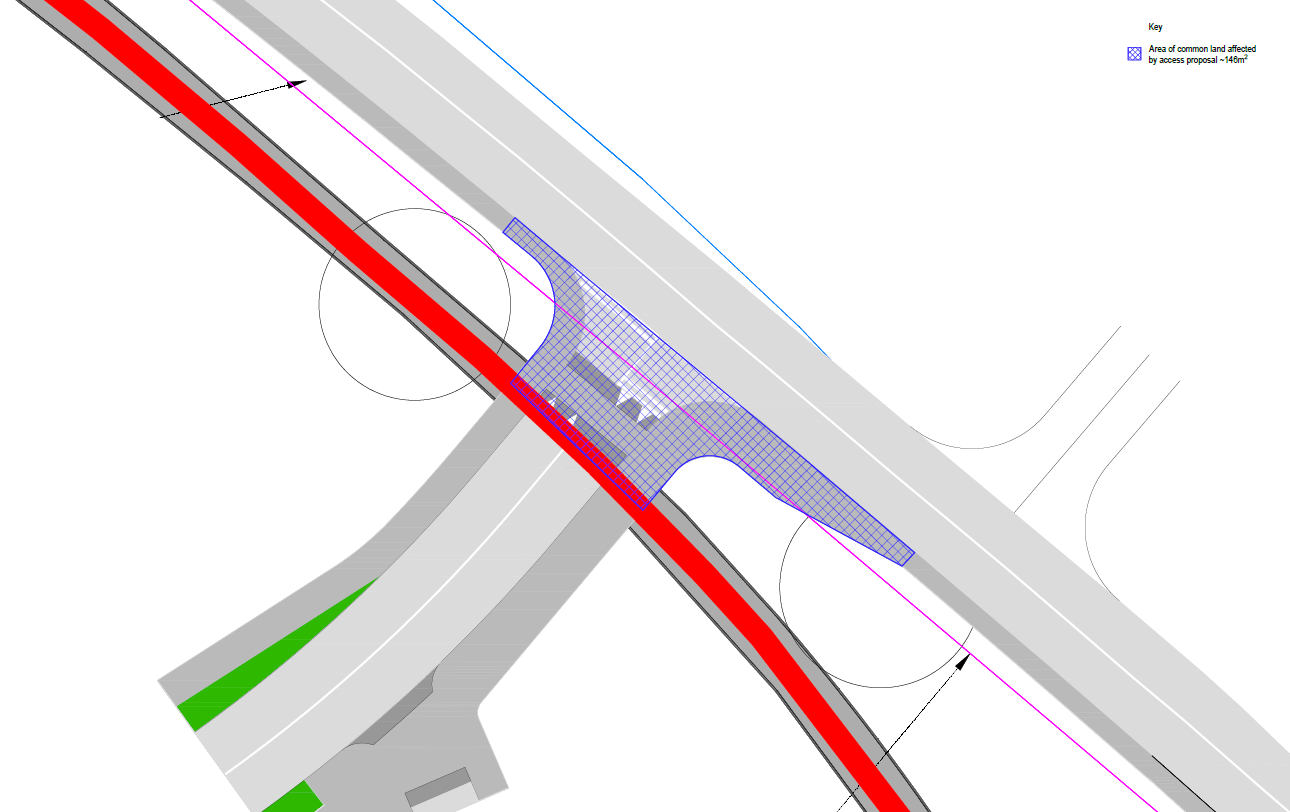
The land in question relates to an area of verge measuring 146m2, located on the south side of Dunsfold Road, as illustrated hatched in blue, in the figure below.
The Land does not adjoin any other area of Common land entries or a village green.
There are no existing Public Rights of Way (PROW’S) or Permissive Pathways, on the Land therefore the proposed works will not exclude or restrict any other rights of access (other than the rights the current Common Land designation grants).
The Land sits outside the boundary of the Surrey Hills National Landscape (formally AONB) and Area of Great Landscape Value (AGLV) and is not located within any area formally designated for environmental, landscape or archaeological features. The site is not within the designated Green Belt.
What works are required?
The proposed works on the Common Land relate solely to means of access to the Site. The works are designed and, if planning permission granted, are to be constructed in accordance with Surrey County Council (SCC) (acting as Highways Authority) adoptable standards in readiness for adoption by SCC under the Highways Act 1980. All material and workmanship will comply with relevant British and Surrey County Council standards.
The proposed access works that affect the Common Land include (but not be limited to) the following:
Road formation for a 6.5m carriageway and 3m footway to both sides. Formation build-up to include where necessary (subject to detailed design) capping, sub-base, base & binder and surface course.
Precast concrete kerbing to carriageway and edging to footway.
Appropriate positive drainage system and service corridors.
Street furniture and signage including street lighting where appropriate.
Road markings.
The works needed to facilitate access to the Site are required to be undertaken at this location, as our assessment has identified it as the only viable route to access the proposed development parcel.
Once operational, the works will not impede any existing public access rights over the Common Land and will maintain the existing footway in this location to ensure that the public interest in this land is not jeopardised.
Replacement Common Land
Subject to the grant of planning permission for the Site, 146 m² of replacement Common Land will be provided in a suitable location, within the Site, to mitigate the loss of land required for the access. The replacement land will be matched as closely as possible to the existing Common Land in terms of character, location, and public utility.
On this basis, it is anticipated that the replacement land will be situated close to the proposed access, adjoining Dunsfold Road; however, the precise location will be confirmed through the Section 38 application.
We're an independent founder-led business, which affords us the freedom to advocate for positive change in our sector. We challenge ourselves, our peers and the government to do things differently and better.
We build strategic partnerships that last, built on a shared vision of what housebuilding should be. Choose us for a quality product designed and built to outlast your investment cycle, while standing the test of time.
Everyone deserves a home they can be proud of. That’s why our affordable homes are built to the same high standard as private homes with no compromise on design, construction materials or care.

Every development we build – and every piece of strategic land we own – reflects our commitment to quality and attention to detail. Nothing is overlooked. Everything is carefully considered.
Our latest posts


Stay connected. Sign up to our newsletter

